Queeny Park is just a few minutes north of the Manchester Road alignment of Route 66 as it traverses West St. Louis County. The park has two entrances. If you are traveling West on Manchester, turn right on Mason Road and look for the entrance that says “Dog Museum”. If you are traveling East on Manchester, turn left on Weidman Road to access the park. There is no way to drive from one entrance to the other without leaving the park, but you can walk between the two entrances.
Queeny Park in Summer
When I was young, I used to love to go to Queeny Park to play on the very advanced and unusual playground equipment for the time. Lately I’ve used the park for biking and hiking. There are some paved trails and some gravel surfaced trails. The park is hilly so either way you’ll get a good workout – it’s especially good in my opinion for practicing hill climbing if you’re new to mountain biking. You’ll get enough of a challenge to give you something to work toward but most of the hills are not so difficult that you’ll be overly discouraged. The park is large and there are enough trails to enjoy a moderately long or short excursion depending on what you are looking for.
Yes you read the first paragraph correctly – at the Mason Road entrance there is indeed a Museum of the Dog. I remember the controversy surrounding this Museum when it was first proposed. A lot of people thought it sounded ridiculous – I haven’t visited it myself. It consists of a collection of artwork devoted dogs in an historic circa 1853 house. I’ve had very enjoyable visits to a barbed wire museum and a vacuum cleaner museum which probably sound like very odd attractions to most, so who knows, it might be good – perhaps it’s worthy of the tradition of eccentric attractions on Route 66. There are lots of dog walkers in the park so there does appear to be a large built-in audience! If you’re traveling Route 66 with canine companions this might be an especially good stop to make – dogs are allowed in the museum and you can give your pets and yourself a workout on the trails.
On Saturday, April 7, 2012, I joined members of the St. Louis Adventure Group (SLAG) for a float on the Meramec River. The Meramec is a prominent feature of the Route 66 corridor from Phelps County to St. Louis County, where it makes it’s way toward the Mississippi River. It is visible from Route 66 in St. Louis County and crosses paths at Valley Park and Route 66 State Park. Once you leave St. Louis County you will have to travel a little way off of Route 66 to see the Meramec River at spots such as Onondaga Cave State Park, Meramec State Park or Robertsville State Park. In between the parks are additional points where you can put in and take out boats.
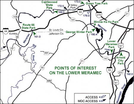
The Missouri Department of Conservation has provided maps to show where the put-in points are. On our April 7 float, we put in at Pacific Palisades Conservation Area (147.3 on the map below) and Allenton Access (154.2).
Meramec River Access Points
This was a fairly short float. We stretched it into about three hours by really taking our time. It was also easy – there are only a few spots where you really have to pay attention to navigate around snags that always seem to be right where the current is swiftest! Our group was made up of experienced paddlers but the Meramec River should always be respected regardless of experience level – it is deep and fast enough to drown people, so if you are going to float it please be sober, make sure you can swim, and use a personal floatation device. You might consider carrying a knife on your person to cut yourself free in case you get tangled in anything. Read here for more safety tips and legal guidelines.
After the float, several members of our group headed to Super Smokers (a Route 66 Association of Missouri Business Member) for a delicious BBQ dinner. We were very impressed by the swiftness at which they served our large group. The food was fantastic!
If you would like to try one of Missouri’s many beautiful float streams but don’t own a boat or need a shuttle, check out our list of Business Members – there are a couple of outfitters on there who will happy to tell you about their offerings.
If you’re traveling on the Manchester alignment of Route 66 through St. Louis County and are in the mood for a short, easy bike ride or a walk for you or a canine companion, try the Rogers Parkway in Brentwood, Missouri. Brentwood is a small city but has a lot of little parks, most with water, some with restrooms. You’ll pass through several during the route I’m about to describe. You won’t see anything spectacular, but you’ll enjoy charming older suburban neighborhoods with large trees and pleasant shade. The trail is pet-friendly with plastic bag dispensers for waste and a water fountain with a basin at dog’s height. If you don’t know the area well you’ll want to download and print out this map to take with you.
If you’re traveling west on Manchester, start looking for the trailhead shortly after you cross over Hanley Road. The trailhead will be on the right, in between American Locksmiths and Brentwood Place Apartments. You’ll find an asphalt trail heading north that takes you to Broughton Park. Follow the trail until you reach Swim Club Road, where you’ll cross over to the other side of the street.
Intersection of Trails
Continue until you get to an intersection of asphalt trails. Turn right, and you’ll pass some handball, tennis, and volleyball courts. This is Hanley Park. You’ll see some signs along the way suggesting different fitness exercises that you can do if you like. The trail splits in two, and the more interesting route is to the right. You’ll cross a creek and follow along it for awhile on the Lee Wynn Trail until you get to Oak Tree Park. If you feel like doing some hill climbing, you can continue past the park and up a ridge to explore the streets a bit. If you’re not in the mood for climbing a hill, head back the way you came until you get past Hanley Park and back to the intersection. You can turn left here and get back on the Rogers Parkway, or you can turn right and continue for a short distance into Memorial Park. If you’re hungry or thirsty, there is usually a snack stand set up here. If you care to head toward the huge American flag toward the northeast, you’ll come across a large shopping center that has a Trader Joe’s and a Target, both places where you can pick up some items for a picnic lunch. (If you turn right at the huge flag and continue for a few blocks, you’ll see some light rail tracks – turn left and there is the Brentwood I-64 Metrolink station if you want to explore more of the St. Louis area – bring your bike on board). If you don’t want anything from the shopping center, I recommend turning around in Memorial Park and heading back the way you came at this point – you’re roughly 2/3 of the way through the entire route if you’ve taken no detours.
If you’re on foot, you’re probably satisfied with the length of your excursion, but if you want a little more, you’ll notice some dirt trails on the right as you head back. Explore the small wooded area if you like.
If you’re on a bike, you might want to extend your ride considerably. If so, I recommend looking for Eulalie Ave. (this is the spot where you crossed the road previously upon reaching Swim Club Road) on the way back. It’s a little confusing because if you look left, the road is called Dorothy and if you look right, the sign is missing. Nevertheless, take a right turn and you’ll come to an intersection with Brentwood Blvd. Use the light and cross Brentwood Blvd. here with care – it’s very busy and the drivers are not necessarily attentive to cyclists or pedestrians.
Once you’ve crossed Brentwood Blvd., continue west on what is now Litzinger Rd. Look for four Lustron houses on your left. Continue for several blocks on Litzinger until you get to Tilles Park, a large park in the city of Ladue with a nice trail, more fitness stations, water, restrooms and more. There is a small lake with a shelter if you’ve brought a picnic lunch. Go around the park as many times as you like, then head back to Brentwood Blvd. on Litzinger and cross back over. Make a right when you reach Rogers Parkway and you’ll be back to the trailhead shortly.
Let’s face it, Route 66 trips have the potential to be hazardous to one’s waistline. We sit in a car for hours a day and when we stop, it’s often for delicious road food – fried chicken, BBQ, burgers, fries, shakes, mashed potatoes, pie, biscuits and gravy, omelettes, hash browns, onion rings, bratwurst, Cozy Dogs, Mexican food, pizza, breakfast burritos, Ted Drewes concretes, mmmmm! I’m not one to deny myself a treat when I’m on a trip. I’ve also been on a fitness kick for the last couple of months and have been trying to work in some kind of exercise every day. Since I live close to Route 66, a lot of the places I go are convenient to people who might be looking for a place to get some exercise while on a Route 66 journey. This is the first of what I hope will be an ongoing series on places to take a walk or a bike ride to work off a little of that road food.
River Des Peres Greenway Trail, looking south just after crossing over Chippewa.
I had an excellent bike ride yesterday on the River Des Peres Greenway in St. Louis, which is also suitable for walkers. A good place to park is the Metrolink Station at Landsdowne and River Des Peres Boulevard. It’s easily accessible from Route 66. As you’re heading west on Chippewa, shorty after you leave Ted Drewes after having your concrete, you will cross the River Des Peres and come to an intersection with River Des Peres Boulevard. To get to the Metrolink Station, turn right. Park, cross Landsdowne Ave., and start off in a southerly direction on the paved trail that is to the right of River Des Peres Blvd. You will shortly come to a bridge with a sidewalk that crosses over Chippewa where you can get a good view of Route 66 in either direction. Depending on your time and inclination you can keep following the trail for several miles.
Along the way you will see the historic River des Peres Sewerage and Drainage Works, a designated National Historic Civil Engineering Landmark. Don’t let the name scare you. Although the portion of the river you will see is not in a natural state, it is not ugly or smelly. (Having said that, if anyone asks you to join the River Des Peres Yacht Club, decline.) The river channel itself, rocked in with limestone by WPA workers in the 1930s, is an impressive sight and the small rustic buildings you see here and there are quite attractive. New structures such as entrance gates and bridges have been constructed in a harmonious style. The trail runs parallel to River Des Peres Boulevard in a wide grassy area with scattered trees between the road and suburban neighborhoods. I found the trail to be smooth and suitable for either mountain or road bikes. Enjoy!
On Saturday, March 19, 2022 my Dad and I drove from St. Louis County to Sullivan, Missouri to attend a neon sign re-lighting ceremony at the historic Shamrock Court. The Shamrock Court is being restored and plans are to re-open it as a motel in the not too distant future. Members of the Route 66 of Missouri and many other volunteers are helping to restore the property, with labor, fundraising, and other opportunities.
The Route 66 Assocation of Missouri Neon Heritage Preservation Committee (“NHPC”) has assisted a lot of historic property owners in various ways to get their neon signs restored. Here is a web page with a list of some of their neon sign success stories. It’s customary for Route 66 Association of Missouri members and allies to get together for a celebratory re-lighting ceremony whenever a historic Route 66 property in the region lights up the newly restored signs for the public to enjoy. March 19 was the Shamrock Court’s turn to shine.
Left: Dad (in red hat) and roadie friend Fred Zander. Center: A big, beautiful party! Right: “It’s so comfortable on the ground here!”
Route 66 events often incorporate car shows, and this night was no exception. Cool cars and trucks filled the parking area in front of the Motel and spilled over into the adjacent street, appropriately named Shamrock St. In keeping with the motel’s theme and proximity to St. Patrick’s Day, it was also a St. Patrick’s Day party complete with Leprechaun, Lucky Charms, wearin’ o’ the green, and lots of Irish luck bestowing fine weather upon us.
On a day so beautiful, my Dad and I left early so that we could go for a hike on the way there. There are lots of choices of places to hike between our homes and Sullivan – we are very blessed to live in Missouri which has abundant parks and trails. We considered several locations then decided on Robertsville State Park. It’s one of the closest State Parks to where we live, but since when we drive by it we are usually on our way to somewhere farther away, believe or not neither of us had ever been there! The one previous time in all my years of 66-ing (23!) that I tried to take a short detour off of historic Route 66 to check it out, I had to turn back because of a flood. So we decided now was the time to try something new and go finally go there. We drove around to see what the park contained and chose two short trails to hike on.
Left: beautiful blue sky and trees not yet leafed out. Center: frog or toad eggs in an ephemeral forest pool. Right: ornate cast iron post in the Roberts family cemetery.
The park was perhaps not in it’s full glory two days before the start of spring, when there is almost no green vegetation to see yet and the ground is saturated from late winter and early spring rains. Nevertheless, we found plenty to appreciate. I have not lost my childhood fascination with ephemeral spring pools. I’m intrigued mostly because I like to look for frog eggs and tadpoles, but they also have quiet beauty in their own right. They are usually clear and still and any vegetation or critters in the water look especially beautiful in such water bodies. As a special treat for me, one of the pools we saw did contain many masses of frog or toad eggs, and some free-swimming tadpoles! I looked at one mass up close to see the different stages of development of the tadpoles. They ranged from little dots to almost ready to emerge, with feathery gills developing and eyes looking right at me! I returned the egg mass to the water and prayed that they would all get a chance to hatch while the pool is still wet.
There is something to enjoy in every season in the magical Missouri Ozarks!
For more information about the re-lighting event and the Shamrock Court project:
Tom and I are pictured removing invasive honeysuckle and euonymus from the Shamrock Courts in Sullivan, MO. In the center all the volunteers are having a lunch break.
On November 7 and 8th, 2020, members of the Route 66 Association of Missouri and other volunteers worked on a historic preservation project at the Shamrock Courts in Sullivan, MO. The Shamrock Courts were an historic Route 66 motel that was later converted to apartments and then left empty for over a decade. The goals of the volunteers on this cleanup weekend were to preserve the buildings, get the property cleaned up and looking good to help it find a good buyer who will restore it, and to look for artifacts and history to pass on to the new owners and to the historic record of Route 66.
I was only able to go on Sunday the 8th because I had a lot of homework, but was nevertheless very pleased to make my contribution. My husband Tom joined me. I concentrated on removing invasive vegetation from the building and the surrounding property. Removing the invasive vegetation helps with preservation because it prevents fast growing trees and vines from gradually prying apart bits of the buildings. In addition taking seeds and parts of the plants that can grow away from the property helps to prevent regrowth and the cost of future labor to remove it. I may be back because there is a lot more to do!
Artifacts that thrill Route 66 fans
When you can find actual historic details and artifacts, it’s an extra reward. For Route 66 fans, to see the outside of buildings like this is exciting, but it’s even better when you can get permission to get close and even go inside to discover things that you may not ever see during a “drive-by” photo op visit, or in a book. Historic finds, like the neon sign tubing we are holding up in the center photo, add to the historic value of the property as well as the satisfaction for history-loving owners and volunteers.
Personally, the day I spent at the Shamrock was extra special because it was on the 21st anniversary weekend of attending my first Route 66 Association of Missouri meeting and the first weekend of exploring Route 66 in Missouri with my Mom and Dad. We stayed at the Boots Motel and stopped for classic roadside sights for the first time such as Red Oak II and Bill’s Station. The following year I became a lifetime member of the Route 66 Association of Missouri!
The following is an assignment for my class MEDC 5350: Media Organization Regulations at Webster University. This one has some pictures in it, so I thought it might be a nice change from the walls of text I’ve been publishing lately! The only thing I changed since turning it in is rewording some references to graphics because it’s formatted slightly differently. It’s also available as a Word document here: “The Holiday Inn Brand and Trademark Concepts” Word Document.
The Holiday Inn Brand and Trademark Concepts
The Holiday Inn brand is a fertile source of imagery for examining legal issues concerning trademark tacking and trademark infringement. The book “American Signs: Form and Meaning on Route 66” by Lisa Mahar examines the motel signage along the historic highway US Route 66 from 1938 to the 1970s in order to explain the economies and cultures behind the forms and themes of motel advertising signs of the time period (Mahar 10). The Holiday Inn lodging chain was founded during this era and the imagery associated with the Holiday Inn brand was influenced by and in turn influenced trends in the motel industry throughout the whole country (Mahar 122, 127).
Credit: “American Signs: Form and Meaning on Route 66” by Lisa Mahar, 2002. Excerpt from page 134.
The diagram above (Mahar 134), demonstrates minor differences in the Holiday Inn logo and signage from 1952-1957. The use of a star and a certain script lettering style is consistent even though the arrangement and number of elements is slightly different.
The following examples show how Holiday Inn added and subtracted elements and slogans to go along with its earlier trademarked elements. The Holiday Inn logo, both one-line and two-line, are registered. The Holiday Inn sign is registered with the US Patent Office, as is the colonial mascot figure that showed up on some advertising pieces and then was later dropped again. The slogans “The Nation’s Inkeeper”, “The World’s Inkeeper” and “Your Host from Coast to Coast” were all registered. The brand’s use of the colors green, yellow and white are consistent in these samples, mostly from the 1970s.
Various Holiday Inn trademarks, mostly from the 1970s.
Holiday Inn marks demonstrate how “words, designs, colors and other devices” were used to distinguish its services from other lodgers from the 1950s through the 1970s (Trager 523). Trademark tacking is the practice of making changes to a trademark without relinquishing the old marks (Trager 519). The Holiday Inn samples shown above illustrate trademark tacking as the color scheme and script font were used over a long period of time, with other elements such as the stars and colonial mascot added and subtracted.
Following are some examples of motel signs from the classic Route 66 era that are similar to the Holiday Inn sign, to varying degrees. By looking at the dates and contexts of these signs, it seems apparent that the first Holiday Inn sign from 1952 incorporated some elements in signage that were already in use, but as the chain in turn became popular other signs for independent motels were more directly influenced by the Holiday Inn chain (Mahar 126-127).
Did the independent motels with signage similar to Holiday Inn engage in trademark infringement? The use of stars, the sign elements and shapes, the name “Holiday” and the color green were all used in various ways as a result of Holiday Inn’s influence (Mahar 127).
Credit: “American Signs: Form and Meaning on Route 66” by Lisa Mahar, 2002. Diagram from page 127.
The law uses the likelihood of consumers becoming confused as one of the criteria to determine whether or not there is infringement (Trager 518). It is not enough for the marks just to be similar (Trager 519). The combination of sign elements with Holiday Inn’s colors and name recognition seems to be distinctive enough to avoid confusion with other brands who might have used a subset of the elements used by Holiday Inn but not all of them combined together.
Works Cited
Advertisement for Holiday Inn. Inkeeker’s Supply Company, Memphis, TN. Circa 1970s. Author’s personal collection.
—. Stationery sheet. Holiday Press, Circa 1970s. Author’s personal collection.
—. Business reply letterhead. Holiday Inn Lake of Ozarks, Lake Ozark, MO. Circa 1970s. Author’s personal collection.
—. Rate sheet. Holiday Inn Lake of Ozarks, Lake Ozark, MO. Circa 1970s. Author’s personal collection.
—. IMART, Memphis, TN. Circa 1970s. Author’s personal collection.
—. Back of business reply envelope. Holiday Inn Lake of Ozarks, Lake Ozark, MO. Circa 1970s. Author’s personal collection.
“American Signs: Form and Meaning on Route 66” by Lisa Mahar, 2002.
“Motel Sign to Get Face Lift.” Between Friends, Vol 2, Issue 2, Fall 2003, pp. 1.
Rest Haven Court. DePew Advertising, Reeds Spring, MO. Postcard. Author’s personal
collection.
Trager, Robert Susan Dente Ross and Amy Reynolds. The law of journalism and mass
communication. Sixth Edition. SAGE Publications, Inc. 2018.
Winkelmann, Carolyn Hasenfratz. Photograph of Munger Moss Motel. 2006. Author’s personal collection.
—. Photograph of the Gardenway Motel. April 2000. Author’s personal collection.
—. Photograph of Vernelle’s Motel. April 2000, Author’s personal collection.
Here are some more excerpts from my homework for Strategic Communications Applications class as we wrote and commented on a discussion board about Corporate Social Responsibility (CSR).
Examples Of Corporate Social Responsibility
Hampton Inns
In the late 1990s and early 2000s, Hampton Inns encouraged tourism on Route 66 and other historic roads and endeared themselves to a lot of Route 66 fans by sponsoring preservation projects along the route. The program was called the Hampton Save-A-Landmark program. I was made aware of the program through my own personal intense Route 66 fandom and related Route 66 news sources and events.
Sites that were targets for the preservation program received help with preservation projects along with a large and attractive signs for each sponsored location that was branded with Hampton Inns and the Save-A-Landmark graphics. The signs raised awareness among the public that the site was significant. Some historic Route 66 and other old roadside attractions are of an importance not always apparent to those not in the know about historic road trip subculture – they often look quite humble and unassuming. The signs helped to raise awareness of Hampton Inns also. From personal experience I know some Hampton Inns were patronized by many Route 66 devotees, at least during the time the campaign was running, even though sometimes the Hampton Inns were a little more expensive than the usual hotels the roadies usually patronized. Awareness of Route 66 makes road trips more fun and getting more drivers out on the roads is good for all businesses along the road including Hampton Inns. It makes sense for a large chain business to take action that helps all tourism as well as mitigates some of the bad feeling among preservationists when large chain businesses make it difficult for smaller historic businesses to survive.
Hampton Inns also made some Save-A-Landmark program branded games meant as giveaways for kids. Some of these games ended up in the hands of collectors (I still have one!) because they provided cases of them to the Route 66 community to distribute at Route 66 events. Adults grabbed some for their collections after the kids who were present got theirs. I loved this game idea because when I was young we had a Stuckey’s board game that I loved to play. I wish we still had it! Games are a great way to build brand loyalty in the young, to have fun and to educate. If I could, I would still patronize Howard Johnson’s, Stuckey’s and A&W often while on road trips. These places are rare now, but are brands I enjoyed very much in childhood. These brands have a place in my collections of road memorabilia because I enjoy the personal memories, the graphics and the history.
Ozark Outdoors is a resort and outfitter that services the area of the Missouri Ozarks where the Huzzah, Courtois, and Meramec rivers meet. Like several other float trip outfitters in Missouri, they give out mesh trash bags to their patrons and provide trash receptacles at the take out points to encourage and enable floaters to dispose of their trash responsibly. In addition, Ozark Outdoors has donated the use of shuttles, vessels and trash pickup containers in their role as sponsor of Operation Clean Stream for several years. Operation Clean Stream is a volunteer effort to pick up trash from land and bodies of water to clean up waterways and the environment in general. Ozark Outdoor stands to get more visitors if the rivers that they serve remain clean and beautiful so it makes sense for them to sponsor such an activity. The humans and wildlife in the area and downstream all benefit from clean water too.
On Saturday, August 24, 2019 Tom and I participated in Operation Clean Stream sponsored by the Open Space Council and many other supporting organizations. I’ve done several of these trash cleanup floats before but this was Tom’s first time. We had a blast because we love to get dirty, we want to do our part to keep our rivers clean and any excuse to get out and be on the water is a good one! We brought our kayaks to the beach on the Meramec River and met up with other volunteers who brought their own vessels. The people I end up floating with on these cleanup days are terrific and we hope we get to float with these folks again. I floated with leader Tim before in 2016 – here is an article I wrote about that day: Fit and Healthy on Route 66: Two Sections of the Lower Meramec – Part I
Here is Tom around 7:30 am untying our kayaks that I transported on top of my Jeep. You can tell by his body language he is pretty eager to get started!
Here is our group’s trash haul in the foreground at Greentree Park in Kirkwood. We were pretty exhausted by this point but the Open Space Council fed us a nice lunch to revive us a little for the trip home! Loading the kayaks is easy in the morning, not so easy in the afternoon!
Some of the members of our group share their favorite finds on a sandbar near Highway 141: https://youtu.be/vrrsEfZF8qg
Water hyacinth I collected on the Meramec River on August 24, 2019.
I found some water hyacinth along the way and picked up as much as I could. I want to use it in our pond which should be finished soon, but even more importantly I want to get it out of the natural body of water because it’s an invasive species. More info about water hyacinth here: http://stopaquatichitchhikers.org/hitchhikers/plants-water-hyacinth/
This is the first time I can recall seeing water hyacinth in a natural body of water in Missouri. Our winters should kill it – that may or may not mitigate the threat – I don’t know. What if some floats downstream to a warmer state? That’s why I grabbed as much as I could. Here is some Missouri specific information: https://mdc.mo.gov/conmag/2008/01/not-state
It was only a few days after my participation in Operation Clean Stream on the Meramec River that a fellow member of the St. Louis Adventure Group Meetup suggested a float from Sunset Hills to Arnold. Kelly was trying to experience some sections of the Meramec that he had not yet floated and I’d never been on that stretch either so I agreed to join him on September 2, the Friday before Labor Day.
This part of the Meramec would not be everyone’s idea of a great place to paddle because it doesn’t have the fast-moving crystal clear water that many of our Missouri streams are known for but I enjoy large rivers and bodies of water that require a lot of paddling. I don’t mind semi-urbanized areas because I enjoy exploring around bridges and other large scary structures. When I was a kid, on occasions when my Dad would take us boating on Lake of the Ozarks or Table Rock Lake, if he piloted the boat too close to a dam or bridge I would scream and cry. I don’t scream and cry if I get close to a bridge now but I do get a weird kind of thrill from it. I probably would scream and cry if I got too close to a dam – even the little tiny one at Creve Coeur Lake gives me a queasy feeling!
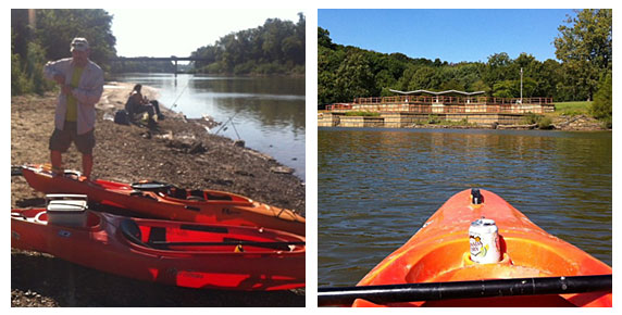
Kelly’s plan was to meet at what would be our takeout point, Arnold City Park, where his neighbor would meet us to kindly help us with our shuttle. Our put-in point was at Minnie Ha Ha Park in Sunset Hills, a 10 mile float by river but only a 10 minute drive from one point to the other. This route is a very efficient way to get in a lot of paddling for a small expenditure of driving time.
On the left is Kelly with our boats at Minnie Ha Ha Park. Since it was a weekday and the holiday weekend had not started yet there were a few people fishing but not much traffic on the river – most of the time we had it to ourselves with only fish, turtles and birds for company. The picture on the right is of George Winter Park, located where the river bulges out in a strange manner as you can see from the map at the top of this article. Kelly explained that much sand and gravel has been and is being mined from the vicinity causing lake-like sections that are a lot of fun to explore.
A few times during the day we pulled onto a gravel bar to stretch our legs a bit or eat lunch. There are banks that are too steep or muddy to climb out of the vessel but also plenty of gravel bars that are just right. The picture on the right shows the Hwy. 21 bridge in the distance. This section was toward the end of our float and we’d been paddling against the wind for quite awhile so a little time to sit back and drift while taking pictures was welcome.
This last pair of photos shows the remains of the boat ramp at Arnold City Park on the left and the Lemay Ferry Rd. and Hwy. 55 bridges on the right (the Hwy. 55 bridge is the one in the distance). Flood damage has rendered this boat ramp pretty useless to all but small watercraft like ours. If you can’t hand-carry your boat down to the water look for another boat ramp to use. The rocky shoreline was not that easy to disembark from either, I did it without falling on my butt but it was close. My footwear for the day was imitation Crocs – something sturdier would have been safer for scrambling around on the rocks and debris.
Our float took about five hours including a stop for lunch and maybe an extra hour and a half or so for shuttling, loading and unloading. We could have added more padding miles by more thoroughly exploring all the little coves and inlets but we only did a few. If you float this section, a map would be a good idea because the geography can be confusing. There is not a lot of shade along the way so make sure you have plenty of sunscreen! Watch out for jumping Asian carp – I don’t know if there is anything you can do about them but be aware just in case. None hit me or jumped in my boat but a group splashed me pretty good and put a momentary scare into me! The myriad of parks along the Meramec are worth exploring on foot and by bicycle. The natural flood cycle of a river can take things away but it also gives by making some land suitable for recreation rather than development. Enjoy!


