It was only a few days after my participation in Operation Clean Stream on the Meramec River that a fellow member of the St. Louis Adventure Group Meetup suggested a float from Sunset Hills to Arnold. Kelly was trying to experience some sections of the Meramec that he had not yet floated and I’d never been on that stretch either so I agreed to join him on September 2, the Friday before Labor Day.
This part of the Meramec would not be everyone’s idea of a great place to paddle because it doesn’t have the fast-moving crystal clear water that many of our Missouri streams are known for but I enjoy large rivers and bodies of water that require a lot of paddling. I don’t mind semi-urbanized areas because I enjoy exploring around bridges and other large scary structures. When I was a kid, on occasions when my Dad would take us boating on Lake of the Ozarks or Table Rock Lake, if he piloted the boat too close to a dam or bridge I would scream and cry. I don’t scream and cry if I get close to a bridge now but I do get a weird kind of thrill from it. I probably would scream and cry if I got too close to a dam – even the little tiny one at Creve Coeur Lake gives me a queasy feeling!
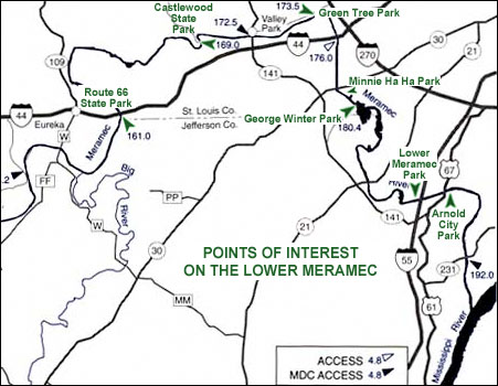
Kelly’s plan was to meet at what would be our takeout point, Arnold City Park, where his neighbor would meet us to kindly help us with our shuttle. Our put-in point was at Minnie Ha Ha Park in Sunset Hills, a 10 mile float by river but only a 10 minute drive from one point to the other. This route is a very efficient way to get in a lot of paddling for a small expenditure of driving time.
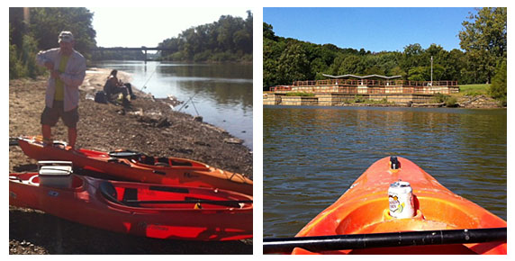
On the left is Kelly with our boats at Minnie Ha Ha Park. Since it was a weekday and the holiday weekend had not started yet there were a few people fishing but not much traffic on the river – most of the time we had it to ourselves with only fish, turtles and birds for company. The picture on the right is of George Winter Park, located where the river bulges out in a strange manner as you can see from the map at the top of this article. Kelly explained that much sand and gravel has been and is being mined from the vicinity causing lake-like sections that are a lot of fun to explore.

A few times during the day we pulled onto a gravel bar to stretch our legs a bit or eat lunch. There are banks that are too steep or muddy to climb out of the vessel but also plenty of gravel bars that are just right. The picture on the right shows the Hwy. 21 bridge in the distance. This section was toward the end of our float and we’d been paddling against the wind for quite awhile so a little time to sit back and drift while taking pictures was welcome.

This last pair of photos shows the remains of the boat ramp at Arnold City Park on the left and the Lemay Ferry Rd. and Hwy. 55 bridges on the right (the Hwy. 55 bridge is the one in the distance). Flood damage has rendered this boat ramp pretty useless to all but small watercraft like ours. If you can’t hand-carry your boat down to the water look for another boat ramp to use. The rocky shoreline was not that easy to disembark from either, I did it without falling on my butt but it was close. My footwear for the day was imitation Crocs – something sturdier would have been safer for scrambling around on the rocks and debris.
Our float took about five hours including a stop for lunch and maybe an extra hour and a half or so for shuttling, loading and unloading. We could have added more padding miles by more thoroughly exploring all the little coves and inlets but we only did a few. If you float this section, a map would be a good idea because the geography can be confusing. There is not a lot of shade along the way so make sure you have plenty of sunscreen! Watch out for jumping Asian carp – I don’t know if there is anything you can do about them but be aware just in case. None hit me or jumped in my boat but a group splashed me pretty good and put a momentary scare into me! The myriad of parks along the Meramec are worth exploring on foot and by bicycle. The natural flood cycle of a river can take things away but it also gives by making some land suitable for recreation rather than development. Enjoy!