Category Archives: Outdoor Fun

Introduction to Letterboxing

Letterboxing logbook and stamp

What is Letterboxing? It’s a fun outdoor hobby that is kind of like a lower-tech version of Geocaching. Letterboxers hide small, weatherproof boxes in publicly accessible places (like parks) and distribute clues to finding the box in printed catalogs, on one of several web sites, or by word of mouth. Individual letterboxes contain a notebook and a rubber stamp, preferably hand carved or custom made. Finders make an imprint of the letterbox’s stamp in their personal notebook, and leave an impression of their personal signature stamp on the letterbox’s “visitors’ book” or “logbook” — as proof of having found the box and letting other letterboxers know who has visited. Many letterboxers keep careful track of their “find count”. Letterboxing is a creative way to enjoy the outdoors!

In this class you’ll get introduced to the basics of the hobby and learn to make two of the items that participants use – a hand-carved rubber stamp and a handmade log book. The skills you will learn while making these items can be used in a lot of other craft pursuits, such as art journaling, card making, scrapbooking, printmaking and much more.

Each class attendee will receive a printout with a written tutorial for that class so if you forget anything we learned you can refer back to it later. All materials are included in the class price.

You will have time for lunch and there are lots of good places to eat or pick up food in downtown Maplewood.

NEW! At each class, there will be at least one door prize randomly awarded to an attendee – probably a craft supply item of some type that relates to the theme of the class. Past prizes have included a necklace kit, a polymer clay frame kit and a craft stencil. That’s my way of saying thank you for coming!

What to bring
It’s not necessary to bring anything but it’s a good idea to wear old clothes in case you get any ink on you. You can bring or buy snacks or lunch. We have a refrigerator for storing food.

What will be provided
I will provide rubber carving material, carving tools to borrow, rubber stamping ink pads to borrow, paper and cardstock to make your logbook and all other materials needed to complete the project during class. Extra supplies will be available to purchase if you want to do more work on your own.

Introduction to Letterboxing
Date: July 16, 2016
Time: 9:00 am – 3:00 pm
Location: Studio:art, 7403 Manchester Road, Maplewood, MO
More information and registration: Class Signup

Book Review: “Into Thin Air” by Jon Krakauer

Book Review: "Into Thin Air" by Jon Krakauer
Book Review: “Into Thin Air” by Jon Krakauer

I haven’t written a book review in quite awhile so it says a lot about Jon Krakauer’s writing that I’m moved to write one now. “Into Thin Air” is his personal account of the 1996 Mt. Everest disaster which is a pretty well-known story. There are two movies about it and several books. I’m interested in outdoor activities so I’ve read a few articles about the incident before reading this book. The articles in no way made me develop an interest in trying high-altitude climbing for myself and this book reinforced my opinion many times over! Just driving my Jeep up the Pike’s Peak Highway in the 90s scared the heck out of me and gave me such a bad migraine I had to take to my bed the rest of the day! I’m very grateful I live at 479 feet above sea level!

I wanted to read this book because I was curious about what it’s like to attempt such a climb and this book gave me a pretty good idea – it’s horrible! Just to get to base camp apparently involves more physical torment than I would ever dream of putting myself through. The kind of person who is willing to try this is a very different breed. I admire such people in a way though I frankly will admit I think they are crazy! Extreme forms of human behavior are interesting to read about.

If you get to the summit you’ve really achieved a major feat of endurance, but it doesn’t sound like any fun at all. To get back down safely is even harder. Many people make the ultimate sacrifice of their lives to try or while earning a living helping others try. There is a lot of money spent, a lot of environmental damage, a lot of cultural changes in the local area and a lot of injuries and mental suffering for some of the survivors in the attempts. Whether or not it’s worth it is a question you will ask yourself if you read the book.

The people in the expedition endured a lot of suffering by their own choice. A lot of people in this world endure suffering without any choice in the matter, so I don’t think this book is exactly inspiring. It is compelling and I won’t soon forget it – one for the permanent library. There are a lot more questions in it than answers and I like that in a book. It will make you appreciate your nice warm bed which is where I read it!

Here are some of my other older book reviews.


Decorating Ideas for Battery Powered Candles

LED Water Lights
LED Water Lights
My part-time employer Schnarr’s Hardware sells a variety of battery powered candles. Some are even designed to be displayed in water. I enjoy using these lights for a variety of decorative effects. If you are doing any holiday entertaining or just want to brighten your home during the gloomy winter months flameless candles are both safe and fun!

Read my posts on the Schnarr’s blog for ideas for displaying flameless votive candles and submersible water lights.

Fit and Healthy on Route 66 – Rogers Parkway to Memorial Park

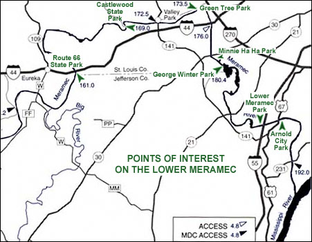
This article was originally published on June 30, 2012 and has been retrieved via the Wayback Machine.

Trailhead for Rogers Parkway, Brentwood, Missouri

If you’re traveling on the Manchester alignment of Route 66 through St. Louis County and are in the mood for a short, easy bike ride or a walk for you or a canine companion, try the Rogers Parkway in Brentwood, Missouri. Brentwood is a small city but has a lot of little parks, most with water, some with restrooms. You’ll pass through several during the route I’m about to describe. You won’t see anything spectacular, but you’ll enjoy charming older suburban neighborhoods with large trees and pleasant shade. The trail is pet-friendly with plastic bag dispensers for waste and a water fountain with a basin at dog’s height. If you don’t know the area well you’ll want to download and print out this map to take with you.

If you’re traveling west on Manchester, start looking for the trailhead shortly after you cross over Hanley Road. The trailhead will be on the right, in between American Locksmiths and Brentwood Place Apartments. You’ll find an asphalt trail heading north that takes you to Broughton Park. Follow the trail until you reach Swim Club Road, where you’ll cross over to the other side of the street.

Intersection of Trails

Continue until you get to an intersection of asphalt trails. Turn right, and you’ll pass some handball, tennis, and volleyball courts. This is Hanley Park. You’ll see some signs along the way suggesting different fitness exercises that you can do if you like. The trail splits in two, and the more interesting route is to the right. You’ll cross a creek and follow along it for awhile on the Lee Wynn Trail until you get to Oak Tree Park. If you feel like doing some hill climbing, you can continue past the park and up a ridge to explore the streets a bit. If you’re not in the mood for climbing a hill, head back the way you came until you get past Hanley Park and back to the intersection. You can turn left here and get back on the Rogers Parkway, or you can turn right and continue for a short distance into Memorial Park. If  you’re hungry or thirsty, there is usually a snack stand set up here. If you care to head toward the huge American flag toward the northeast, you’ll come across a large shopping center that has a Trader Joe’s and a Target, both places where you can pick up some items for a picnic lunch. (If you turn right at the huge flag and continue for a few blocks, you’ll see some light rail tracks – turn left and there is the Brentwood I-64 Metrolink station if you want to explore more of the St. Louis area – bring your bike on board). If you don’t want anything from the shopping center, I recommend turning around in Memorial Park and heading back the way you came at this point – you’re roughly 2/3 of the way through the entire route if you’ve taken no detours.

If you’re on foot, you’re probably satisfied with the length of your excursion, but if you want a little more, you’ll notice some dirt trails on the right as you head back. Explore the small wooded area if you like.

If you’re on a bike, you might want to extend your ride considerably. If so, I recommend looking for Eulalie Ave. (this is the spot where you crossed the road previously upon reaching Swim Club Road) on the way back. It’s a little confusing because if you look left, the road is called Dorothy and if you look right, the sign is missing. Nevertheless, take a right turn and you’ll come to an intersection with Brentwood Blvd. Use the light and cross Brentwood Blvd. here with care – it’s very busy and the drivers are not necessarily attentive to cyclists or pedestrians.

Once you’ve crossed Brentwood Blvd., continue west on what is now Litzinger Rd. Look for four Lustron houses on your left. Continue for several blocks on Litzinger until you get to Tilles Park, a large park in the city of Ladue with a nice trail, more fitness stations, water, restrooms and more. There is a small lake with a shelter if you’ve brought a picnic lunch. Go around the park as many times as you like, then head back to Brentwood Blvd. on Litzinger and cross back over. Make a right when you reach Rogers Parkway and you’ll be back to the trailhead shortly.

Fit and Healthy on Route 66 – Castlewood State Park

Castlewood State Park in St. Louis County, Missouri
View from bluff at Castlewood State Park in two different seasons

Castlewood State Park is located along the Meramec River in the southwest portion of St. Louis County between the Manchester and I-44 alignments of Route 66. Parts of the park lay on either side of the Meramec River. The part that lies north of the Meramec River is accessible by car south of the Manchester alignment of Route 66 and includes one of the most scenic views in all of St. Louis County. The photos above were taken from the River Scene Trail.

In the days before air conditioning, one way people used to cope with the heat was by visiting swimming beaches at the numerous rivers in the region. Caves were popular too. Route 66 fans will recognize the names of the fun places “Times Beach”, “Sylvan Beach”, Meramec Caverns”, “Stonydell” and Joplin’s “Lakeside Park”. Fort Bellefontaine County Park was formerly such a destination – the area that is now Castlewood State Park was another.

According to the book “Walks & Rambles in and around St. Louis” by Robert Rubright, the heyday of Castlewood as a resort was from 1915-1950. The swimming beach was washed away by the river in 1945. Some other amenities such as clubhouses, nightclubs and taverns persisted a bit longer. The state of Missouri converted the land to a park in 1979. Signs at the park indicate that while swimming in the Meramec River is not forbidden, it’s not encouraged either and is something to undertake at one’s own risk. Drownings do occur here so be careful.

The River Scene trail is so nice that I have explored very few other areas of the park despite many visits. I need to correct that oversight! There is a steep climb to the top of the bluff but after that the trail is not too difficult because it is mostly flat or downhill. You will have to watch your footing because the trail is rocky in spots and it’s possible to trip on tree roots. Sturdy hiking boots and a walking stick are helpful for safety and comfort. There are multiple scenic overlooks, historic ruins from the resort days and a well-traveled railroad corridor to see along the way. Rail fans will normally get a chance to see a train or two while hiking here and a portion of the trail even goes under the railroad bed in a cool tunnel.

Map of Castlewood State Park in St. Louis County, Missouri

As you can see from this map, the portion of the park that is South of the Meramec River is accessible only by hiking, biking or by horseback. You can take a trail to Castlewood from either West Tyson County Park or Lone Elk County Park.

It’s not shown on this map how it connects but if you take the Stinging Nettle Loop at the base of the bluff, you can follow that trail westward to a portion of the Meramec Greenway, Sherman Beach County Park and the Al Foster Trail which begins in Glencoe. You can also take a side trip on the Rock Hollow Trail, also known as the “Zombie Road”. The Stinging Nettle Loop is great for mountain bikers like me who are pretty much at the beginner level. There are some hills but they are not too high and if you fall you’ll probably land on dirt most of the time. I took a minor fall and didn’t get hurt. More challenging trails that I have not worked up to trying on a bike yet are in the area if you’re up for it. If you are getting the impression that you can spend days or weeks here exploring all the trails that connect near here you are probably right! Bring maps because it can get confusing!

Castlewood State Park official web site

My photos of Castlewood State Park and the nearby Wildlife Rescue Center

Fit and Healthy on Route 66 – West Tyson County Park

View from the top of one of the ridges in West Tyson County Park

The Interstate 44 / Historic Route 66 corridor southwest of the St. Louis, Missouri metro area is an embarrassment of riches for outdoor enthusiasts. Opportunities for bicycling, hiking, boating, camping, fishing, bird watching and many other outdoor activities are easily available to Route 66 enthusiasts who want to take a healthy break from driving a motorized vehicle. Route 66 State Park is a must-see for the Route 66 fan but there are abundant other interesting choices for outdoor recreation in the area, many with historic connections to Route 66. Route 66 State Park is a great choice for flat walking and biking trails. If you’re in the mood for some hills, take a look at West Tyson County Park. You’ll see the entrance to this park on the way to Route 66 State Park if you take the Lewis Road exit (#266) off of Interstate 44.

Trail at West Tyson County ParkLast weekend I parked at the trailhead for the Flint Quarry Trail loop and started my hike. It was supposed to be about three miles, but there are lots of connector trails to other trails and other parks in the area and I was on another trail for some of the time and ended up hiking just under five miles. All the connectors make this trail kind of confusing, so be sure to have a map with you when you set out. Some of the twists and turns on this trail are extreme which makes it pretty easy to see where you are on the map. Without a map I would have felt apprehensive and it’s possible I would have gotten lost. While the trail is hilly and rocky, the switchbacks are really well done and the climbs tend to be broken up into short segments so I didn’t find it overly strenuous. Besides a map and your normal hiking safety gear, I recommend at least two bottles of water – more if you have room, in case you get off the trail – hiking boots with ankle support and a walking stick to make this hike comfortable and safe. The trails in this area are used by mountain bikers and horseback riders, so be alert and give them room to pass.

The main natural attractions on this trail are scenic views from the ridge tops, beautiful forest and intriguing rocky outcrops which were once mined by Native Americans to make stone tools. If you’re into the hobby of letterboxing, there are some man-made attractions here too for you to try to find. I searched for four letterboxes during my hike and actually found one. That’s typical of my usual ratio I must admit!

Tyson Valley Park Henry Shaw GardenwayOn the restroom / shower building at the trailhead is mounted this commemorative plaque which marks the transfer of ownership of a portion of the park land from the Federal government to St. Louis County. Like many parks in the St. Louis area, West Tyson’s history includes military use in WWII. The tract known as Tyson Valley Park was reclaimed by the U.S. Military in 1951 for use in the Korean War effort and repurchased by St. Louis County in 1963. The article “The Tyson Valley Area” by Conor Watkins helps explain who owned what when and is a great overview of the history and recreational opportunities in the area surrounding West Tyson.

The Henry Shaw Gardenway has its origin in the founding of the Missouri Botanical Garden Arboretum, popularly known as “Shaw’s Arboretum” as the garden itself is popularly known as “Shaw’s Garden”. In 1923 Missouri Botanical Garden purchased land in Gray Summit, MO to house plants that were in danger from St. Louis city pollution. In 2000, this land was renamed “Shaw Nature Reserve” and is a great place to hike and view nature.

In 1935, a portion of Route 66 from the St. Louis city limits to the arboretum in Gray Summit was dedicated as the Henry Shaw Gardenway. The well-known Route 66 landmark Jensen’s Point in Pacific was named after Lars Peter Jensen, president of the Henry Shaw Gardenway Association. It’s difficult to find much more information about the Henry Shaw Gardenway other than it existed and another remnant, a stone bus stop, is now located in the Shaw Nature Reserve. The CCC participated in highway beautification programs throughout the country in the 1930’s and the Henry Shaw Gardenway was one of the roads enhanced by their efforts. Blackburn Park in Pacific is another landmark extant on the Gardenway that I know of. It’s an intriguing part of Route 66 history that I want to know more about.

The Henry Shaw Ozark Gardenway was/is a modern-era organization with the mission of preserving the Ozark foothills along Interstate 44 and promoting maintenance and expansion of the Ozark Corridor series of parks. Their web site is not currently functioning and I don’t know if it’s still in existence. There is a great map of natural resources along the corridor here – Henry Shaw Ozark Corridor.

Insect Repelling Incense Sticks

My brother likes to grill so I made him some incense sticks to keep bugs away while he’s enjoying time in the backyard. They turned out to smell so good that I’ve been burning a few in my studio just to enjoy the fragrance while I work – I felt more relaxed and creative for some reason! (My studio is not near my pet birds’ cage – don’t burn incense or candles near birds!)

Ingredients: Unscented incense sticks, DPG (Dipropylene Glycol), Citronella essential oil, Litsea Cubeba essential oil, Camphor essential oil, insect repelling essential oil blend (contains eucalyptus, lavender, palmarosa, citronella, rose geranium and rosemary), Neem oil, Rosemary Oleoresin Extract (ROE), Lime Citronella soap fragrance.

Instructions: I took out a shot glass and added one eyedropper each of all the ingredients except the DPG and Lime Citronella fragrance. I filled the rest of the shotglass to the top with the fragrance. I emptied the shotglass contents into a glass measuring cup then added three more shotglasses full of DPG and mixed well. I placed the incense sticks in a glass baking dish and poured the mixture over the sticks then covered with foil and let soak for 24 hours. To dry I poked the sticks into a chunk of scrap styrafoam and let sit out. They burned ok the next day but I wasn’t sure they were totally dry so I let them dry a few more days.

The sticks make a good room air freshener until burned so I’m going to store mine upright in a vase. I had some fragrance mixture left over so I stored and labeled that for future use. I’m so pleased with this first attempt at incense making that I’m going to order some natural ingredients for making incense cones from scratch and phase out the synthetic ingredients once they are used up. The smoke smell mixed with the fragrances is so much better than the fragrances by themselves!

Two applications that are making me even more outdoors-mad than I am already!

So far in the St. Louis, MO area we’ve had some really nice weather in April which is an intoxicating antidote to the awful winter we just endured. I’ve been finding it very difficult to stay indoors to actually do any work (except in the garden of course!). As if I needed any more motivation to get outside, I’ve recently tried out a couple of applications that really help pump my enthusiasm.

The first is one that a lot of people have heard of but I only discovered it last week. It’s called MapMyRide.com and since I like to hike, ride my bike, kayak and explore the outdoors, there are a lot of things I can do with this app. On my computer, I can plan out a route and then send it to my smartphone. I can use the smartphone app to record an excursion then look at the map later on my computer. Why would I want to do this? I can look at the map in satellite, road map or topo map view and see if there is anything interesting I missed that I might be able to find on a return visit. Some features are only going to be visible on one of these views so to be able to toggle back and forth is a great help. If I want to share my adventure with others I can take screen shots of the maps to make them into a graphic. Topo maps sometimes show old roads and old place names and can be a help when researching an area. For people who like to explore old roads such as Route 66, the satellite view is a great way to find things that are very difficult to see from ground level. For example, this old cut-off piece of Route 66 had to be shown to me by a guide and I didn’t remember how to get there again. Now I think I’ve found it with the satellite map and will be back to see if I’m right.

What if you are in an unfamiliar area and want to find a bike trail? Or you just want to find some new ones in your own area? You can set the app to show bike trails and zoom out to move along your route. When you see some green lines, zoom in to see details about a trail! It doesn’t seem to have a feature for finding walking trails only but most bike trails are also ok for walkers to use so it’s a good start. When you record your workouts, MapMyRide also tracks the calories burned for you and you can enter in your meals to use it as a calorie counter. And all of these features are in the FREE version.

The combination of MapMyRide and the weather had me so amped up last week that I walked 12 miles and rode 5.35 miles on my bike in six days. That’s not a lot for some people but it is for me. I’ve also started logging my miles on another web site also called 100 Missouri Miles, where the Governor and First Lady challenge you to match their active miles. It includes running, walking, hiking, geocaching, rolling, cycling, paddling, riding, swimming and skating. Missouri residents can use this site to motivate themselves to keep up with other active people. You also get badges when you reach certain goals. There are also features for finding interesting trails and events. A great way to enjoy the “Best Trails State” in America!

Fit and Healthy on Route 66 – Fort Bellefontaine County Park


Fort Bellefontaine County Park on the banks of the Missouri River in North St. Louis County is one of my all-time favorite places for a hike. It’s more than just beautiful – it’s exciting and mysterious. History buffs will get a thrill here because in 1805 it was established as the first United States military fort west of the Mississippi and is the spot where the Lewis and Clark expedition camped on their first night heading west and on their last night of the return trip. The fort also played a role in the war of 1812 and was a trading post where Spanish, French and American traders did business with Native American tribes. The military moved to Jefferson Barracks in what is now South St. Louis County in 1826 and the Fort Bellefontaine site was later taken over by the City of St. Louis who established Bellefontaine Farms, later the Missouri Hills Home for Boys, on this spot. In the 1930s, there was a public beach here and the WPA built a Grand Staircase down the river bluff along with other stone structures intended to draw visitors to the area. The remains are quite a sight. At the top of the Grand Staircase a cannon is displayed. This bugs me because it gives the impression to the uninformed that the Grand Staircase is actually the fort, but unfortunately there are no remains of the fort to be seen. There is one small building on the site believed to be built from old fort foundations, but as far as I know all the other stone work you see here is from the 1930s.

I grew up in North St. Louis County and did not know of the existence of this place until the time of my first visit in 1990. Although the park was acquired by St. Louis County in 1986, as far as I know the only way to visit it in 1990 was by canoe – this is what I was told by my friend Rich, a fellow member of the St. Louis Community College at Florissant Valley Outdoor Club. He heard about it from the faculty mentor of our group, who was an avid canoeist and outdoorsman and knew about all kinds of interesting places to explore. Rich proposed that the two of us put a canoe in where Highway 367 meets the Missouri River, stop off to see the Grand Staircase, continue to the confluence of the Missouri and Mississippi Rivers and cross the Mississippi over to the Illinois side to visit the spot where Lewis and Clark began their trek to the Louisiana Territory and have a picnic lunch. Then we would continue down the Mississippi to pass under the Chain of Rocks Bridge and over the Chain of Rocks falls and take out at North Riverfront Park where we would leave a shuttle car. Canoeing or kayaking the Chain of Rocks falls is not something to be taken lightly even by very experienced paddlers. Fatal accidents are possible.


Well how could I say no to an action-packed itinerary like that? March 2, 1990 had fine weather for such an adventure and all went smoothly. I remember the date because it was one of the most exciting of my life! In the present day, the Missouri River shoreline has been cleared of brush immediately in front of the Grand Staircase but in 1990 that was not the case. After pulling the canoe up on the bank we had to bushwhack through the brush to get to the staircase – not that difficult to do in late winter when there were no leaves on the branches – it was fairly easy to see where to go. The first look at the Grand Staircase was not something to be forgotten and it was many more times as exciting as it might have been because we were not sure we were supposed to be there. We dared to climb the staircase to the top of the bluff and we saw some of the Missouri Hills Home for Boys Buildings. Most were in good repair but I remember one that was more of a moss-covered ruin and we watched snowmelt dripping from it in the bright sunshine with delight at the beauty of the architecture. A nearby stone gazebo still had some of the wood roof structure in place at that time.

I won’t go into detail about the rest of our awesome day except to mention that back in 1990, another thing that was very difficult to see except from a boat was the confluence of the Missouri and Mississippi Rivers. Now there are two public areas – Edward “Ted” and Pat Jones-Confluence Point State Park and Columbia Bottom Conservation Area – that give you access but at the time this area was private farmland.

In the second half of the 1990s, word began to get around that this was a park you could actually go to officially and it became a regular hiking spot for my family and I.


To visit the park, take the Bypass 66 Route westward from the Chain of Rocks Bridge and make a right on Bellefontaine Road and continue until it dead ends. There is a guard gate. Stop there and an attendant will write down your license number, get your name and issue you a parking pass. They usually know why you are there but if they ask just explain that you want to hike. There are a couple of parking spots you can choose, I like the one near the top of the bluff at the Grand Staircase. You will discover that there is a lot more to see than the Grand Staircase. At the base of the bluff is a hiking trail. If you take it to the left, you will follow the Missouri River upstream for a bit until you reach the spot where Coldwater Creek terminates in the Missouri River. Along this segment of the trail are a number of interesting ruins and information signs.

To see the end of Coldwater Creek is especially interesting to me because the creek is a major personal landmark. Where I grew up in Florissant, the creek passed close to our house and some of the best times of my childhood were spent on a wooded trail that ran parallel to the creek and linked two parks and a cemetery. It was not an official trail – the local kids wore it through there! My neighborhood friends and I had what we called our “hideout” which we used to furnish with rugs, drapery and a makeup table (!!??) in a tangle of small trees (which is still there!) near the creek in back of St. Ferdinand Cemetery. Sadly the trail is overgrown now and it’s hard to even see where it might have been, testament to the fact that kids don’t play there any more. Perhaps that’s for the best though. Creeks that function as storm drains are not really safe places for kids and Coldwater Creek, which originates near Lambert Airport, besides being known a huge source of fun for many North County kids, is also notorious for possibly being contaminated with toxic waste and there is suspicion that those who spent time in it or near it might be prone to diseases in adulthood.

The creek is certainly not devoid of life. I don’t know if it contains fish, but there were crawdads in it when I was young (which I used to try to catch of course with little success) and there are still crawdads in it now. It also supports fresh water clams. On a recent Fort Bellefontaine hike we found clam shells of all sizes including some almost as big as my hand! Small frogs are present and we saw evidence of predatory birds feeding on critters – large heron footprints in the mud and collections of excreted crawdad parts!


The trail follows the creek upstream where eventually you can see a very interesting ruin of a lodge which is starting to fall into the creek due to bank erosion. Shortly after this ruin the trail turns uphill. This is the only part of the trail that is at all challenging. After the short climb, the trail forks off. To the right it skirts a pond in an open grassy area. This part of the trail is new. If you take the trail left, this is the route we used to take when we first started hiking here. It takes you past a police dog cemetery and a police dog training area. You don’t see that every day!

Whichever fork you take around the pond, you will be led back to a trailhead at one of the main roads that passes through the youth facility. Follow one of those roads back to the bluff top and you’ll be back at the parking spot. There is a shorter segment of trail on the right, which I’ve only actually been on one time. On the way out, stop at the guard shack and turn in your parking pass and leave with great memories of a really unique place!

For more information:

Fit and Healthy on Route 66: Carondelet Park

I belong to a Meetup group called Let’s Hike and recently we went for a group walk at Carondelet Park, the third largest park in the City of St. Louis. The Village of Carondelet was founded in 1767 and was incorporated into the city of St. Louis in 1870. Carondelet Park was dedicated on July 4, 1876. To get to the Park from Route 66 if you are traveling East to West, take Gravois through the South St. Louis area. Shortly after turning onto Chippewa, make a left turn on Morganford then another left on Holly Hills Blvd. On the way you’ll pass through the Bevo neighborhood with the famous and historic Bevo Mill and across the street from the park you’ll see some really unique and beautiful homes. This Route will take you a little bit off of Route 66 but you’ll get a look at some really authentic living neighborhoods that you won’t see anywhere else.

The most iconic feature in Carondelet Park is the Boathouse overlooking a popular fishing lake. There is another lake plus interesting walls and other stone constructions here and there. There are recreational amenities such as horseshoe pits, ball fields, a playground and nicely paved trail for pedestrians and cyclists circles all. It took our group one hour to circle the park twice on foot. Apparently this is also a great spot for birdwatching – check out these photos! If you walk toward the recreation center on the East side of the park and cross the railroad tracks, you will see a very attractive bridge to the north.

Carondelet Park is being linked to the Great Rivers Greenway system via the new River des Peres: Carondelet Connector. This should be complete very soon and when it’s done you’ll be able to get on your bike at Carondelet Park and take the the River Des Peres Greenway all the way to Route 66 at the intersection of Watson Road and River des Peres Blvd. – the round trip would be formidable but doable for experienced riders.

There are plans for improvements at Carondelet Park that sound very interesting, including something very intriguing to me personally, bird habitat development. Get news about what’s going on the park from the Friends of Carondelet Park Facebook page.